Weather To Swing Into Spring
MetService is
forecasting changeable weather for much of the country this
week, with bursts of rain or showers, snow to low levels
over the South Island, periods of strong to gale force
winds, and wildly swinging temperatures likely. A
strong northwesterly flow ahead of a front is expected to
bring heavy rain to western parts of the South Island
including the Southern Alps today, and severe gales to
eastern parts of southern and central New Zealand. A
period of heavy snow is also forecast for inland parts of
Canterbury tomorrow, and many South Island roads may be
affected by snow. Severe
Weather Warnings and Watches have been
issued. Blustery northwesterly winds will push-up
temperatures in eastern parts of the country today, with
some towns breaking into the twenties. MetService
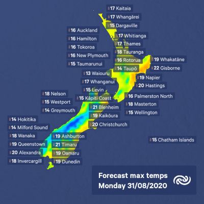
Meteorologist Peter Little explains, “Gisborne is headed
for a high of 22°C today, around 6°C above average for
this time of year, while Christchurch and Timaru are aiming
for 20°C and 21°C respectively, which is 6°C to 7°C
above normal for
them."

|
Advertisement - scroll to continue reading
The front moves up the South Island on Tuesday and the North Island on Wednesday, followed by colder southerly winds. This front will bring a period of rain to most places, with snow down to 300 metres over southern New Zealand. Little comments, “While this forecast snowfall will be excellent news for skiers, snow will also likely affect a number of alpine passes and cause stress to new-born lambs." The southerly change will also knock daytime temperatures back several degrees. “The forecast high for Gisborne on Thursday is 12°C, which is 10°C cooler than Monday, and it’s a similar story for Christchurch with a high of just 10°C forecast for Wednesday," adds Little. Morning frosts are also likely about inland parts of both islands once the weather clears and winds ease. Winds shift back to the northwest by the end of the week, with rain returning to the west of the South Island and daytime temperatures in eastern places rebounding into the high-teens. |


 Gordon Campbell: On What’s Wrong With The Treaty Principles Bill
 Department Of Internal Affairs: Samoan Citizenship Bill Passes Into Law
 NZ National Party: National Acknowledges The Passing Of Hon Nikki Kaye
 Mana Mokopuna: Children And Young People Share Vital Insights On Healing From Family Violence And Sexual Violence In New Report
 NZ Government: PM Marks One Year In Government
 Helen Clark Foundation: Helen Clark Foundation Calls For Political Action To Reduce The Prevalence Of Junk Food And Improve Health Outcomes
 Justice Committee: Further Decisions About Submissions Process For The Principles Of The Treaty Of Waitangi Bill


